The Tongariro Alpine Crossing
Described as 'one of the best one-day hikes in the world' - check out our animated map of the Tongariro crossing
A spectacular 19.4km traverse across some of the most amazing scenery of New Zealand's Central Plateau
If you love the Tongariro Crossing, you might also be interested in completing the Tongariro Northern Circuit, one of New Zealand's 'great walks'.
Video of the Tongariro Alpine Crossing - filmed in October 2018
Special thanks to Sarah and our guide Jah of Adventure Outdoors who took us on an amazing adventure.
Where do I start and finsh the Tongariro Alpine Crossing?
There are two directions that the Tongariro Crossing can be traversed. The most popular of these is the 'west-to-north' direction, starting at the Mangatepopo (carpark) end and finishing at the Ketetahi (carpark) end. Hiking the Tongariro Crossing in this direction is certainly easier - as the elevation drops from approximately 1,100 metres AMSL to 750 metres over the walk.
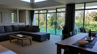
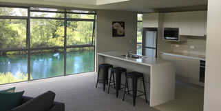
Getting there from Riverside Apartment
Drive through Taupo town along the main road and continue south - the road will lead into State Highway 1. Follow this road along the eastern shores of Lake Taupo to the town of Turangi. Continue south-bound on State Highway 1 for another 10km to then turn right into Lake Rotoaira Road (State Highway 46). (Note that after about 10km you will pass the turn-off for the Ketetahi carpark end of the crossing - where many hikers are picked up after completing the trek). Continue along Lake Rotoaira Road until the junction with State Highway 47. Turn left into SH47 (towards 'National Park') and after approximately 14km you will see the Tongariro Alpine Crossing signposts for Mangatepopo Road (on your left). This is a dirt road - please take care when driving up as buses and tourist shuttle vehicles will often be going in the other direction. Continue up this road until you reach the carpark and the start point for the crossing.
Shuttle options
There are several shuttle-services that can take you on a one-way trip from one carpark to the other if you are driving, or buses that operate a complete dropoff and pickup service. There are parking restrictions from Labour Weekend (October) through the summer open season which limits the time that you are allowed to park in the Ketetahi end carpark.
Guided Tours
We can highly recommend the guided tours provided by Adventure Outdoors. The full package includes transport (pick-up available from Riverside Apartment), gear hire (if needed) and an informative tour provided by an experienced and qualified guide. 10% discount available for guests of Riverside Apartment.
About the Tongariro Alpine Crossing
The distance from Mangatepopo to Ketetahi (and vice versa) is 19.4km. While the distance and terrain are only moderately demanding, it is prudent to remind hikers that this is an alpine crossing and even in summer the weather conditions can be unpredictable and changeable. It is highly recommended that the equipment and preparation guidelines recommended by the Department of Conservation (DOC) be followed. Snow and ice will still be common on parts of the track even in October and November.
The hike will take around 6-8 hours depending on your level of fitness and how many stops you take. There are a few diversions including the Ngaruahoe summit climb that may be followed which will increase the amount of time that you should allow. To run the crossing (again depending on your level of fitness and the number of walkers on the track) will take 3 to 3.5 hours. If you are planning on running the Tongariro Crossing we recommend that you get to the start point around sun-rise as many tourists will start the track early in the morning in the summer months to begin the walk.
The Tongariro Crossing with kids
The track, whilst demanding physically should pose no problems for fit younger hikers, but consider carefully your child's ability and take extra precautions when assessing the weather conditions. The track is in good condition but parts of it are steep. There are stairs and a signfiicant climb up 'Devil's Staircase' and a steep climb to the summit which has a section where a rope or chain needs to be used with one hand. The descent from the summit has loose scoria and stones which will need to be negotiated carefully with younger children.
If you have any doubt about the weather or your child's ability to complete the crossing then there is no doubt - do not attempt it - wait until they are older and/or the weather is great. The Tongariro Alpine Crossing is not the place to be with a child that has run out of energy, or worse, injured themselves. As a guideline, we have taken our ten year old daughter (very fit) on the crossing and she managed it well, late October, excellent weather conditions but we still required waterproof hiking boots and an ice axe for parts of the climb where snow and ice were still found. We took our time and it took 8 hours 45 minutes.
An extra layer of safety can be achieved by booking a guided tour with Adventure Outdoors and remember that they offer our guests a 10% discount on their fees. Mention you are staying at Riverside Apartment when making the booking.
The Tongariro Crossing
The hike itself can be broken up into five broad sections.
1. Mangatepopo Car Park to Soda Springs
A gentle gradient starts our trek as we wind our way up the Mangatepopo Valley. Branches from the track lead to Whakapapa on the right and the Mangatepopo Hut on the left. Dramatic views of Mt Ngaruahoe to our right give a glimpse of what lies ahead as the path rises to approximately 1,300 metres AMSL towards Soda Springs. The track is easily run or hiked and is board-walked for significant sections over swampy areas and an old lava flow. The last toilet facilities (until the Ketetahi Hut) are located at Soda Springs.
Approx time 1:15
2. Soda Springs to South Crater
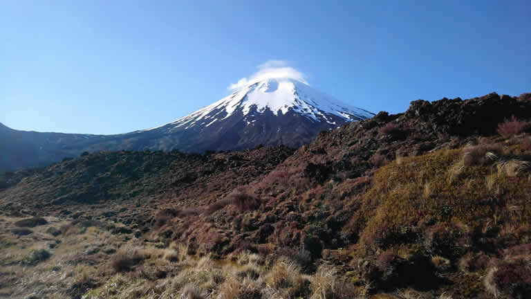
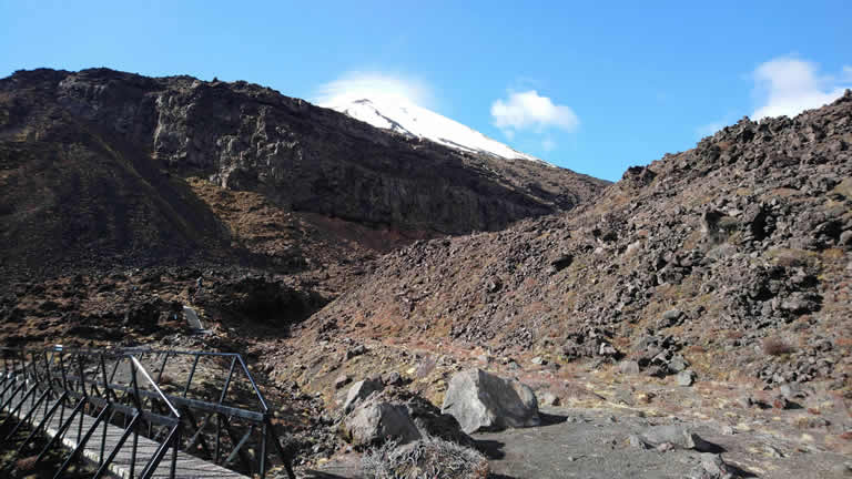
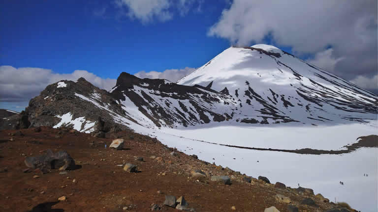
The 'Devil's Staircase' provides a challenging 200 metre uphill climb, but rewards with stunning views back down the Mangatepopo Valley and on a clear day all the way across to the volcanic cone of Mt Taranaki. After the climb it is decision point - veer left to take the track towards South Crater or take on 'Mt Doom' from the Lord of the Rings movies - and climb the vertiginous summit of Mt Ngaruahoe. Climbing the summit of Ngaruahoe in summer is ironically more difficult than in winter - the 'one step forward two steps back' concept becomes evident as the scoria and loose material you're climbing makes for slow progress, however in winter with crampons it is easier to get good footholds.
Approx time 0:50
3. South Crater to Red Crater
The wide open expanse of South Crater is ringed by ruggedly beautiful terrain. Engage the panorama function of your camera for some surreal 360 degree images. Enjoy the easy, flat terrain of this section of the crossing because you are about to start the last major climb of the day, about 250 metres of vertical ascent up an exposed ridgeline covered in loose soil and scoria. An optional diversion towards Mt Tongariro is an option - otherwise follow the well-beaten path towards Red Crater.
Approx time 1:00
4. Red Crater to Blue Lake
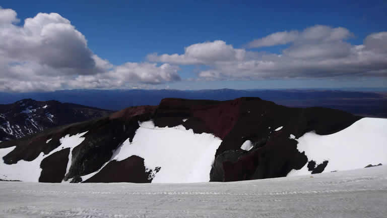
Probably the most memorable part of the entire crossing with scenery that will remain with you a lifetime. Remarkable views across the Oturere Vallery, Rangipo desert and Kaimanawas are a precursor to the phenomenal Red Crater, a cavernous volcanic hole awash with the raw colour of minerals and rock. A steep descent on loose scoria can prove a little dangerous so take care with your footing on this section of the hike as you head downhill - but not before taking in some of the most spectacular views of the entire walk - overlooking Blue Lake and the Emerald lakes below. These lakes remain frozen until thawing in November so if you want the quintessential photos of these cobalt-blue lakes then wait until December to make your crossing.
Geothermal activity forcing its way to the earth's surface as steam vents provides a surreal feeling to this unique place; the acidic waters of the lakes irridescent in blue and green as the minerals leached from the surrounding rock colour the water.
Walk across Central Crater then it's a gentle climb to overlook the Blue Lake from closer proximity. This is the last real uphill excursion.
Approx time 0:30
5. Blue Lake to Ketetahi Hut and Carpark
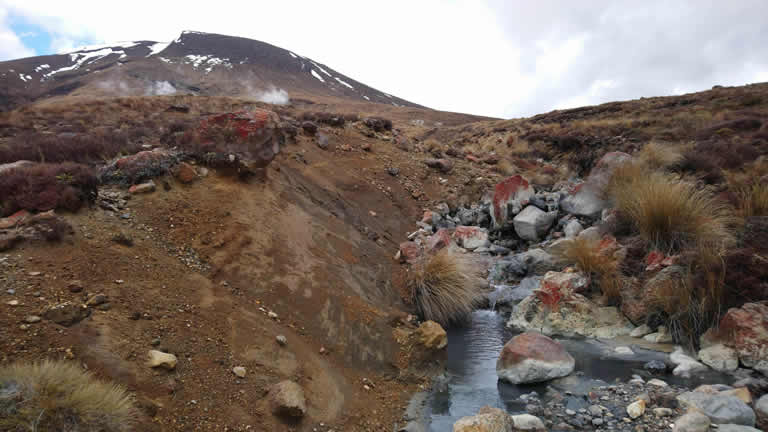
A short climb to the top of the North Crater gives way to a zig-zag path through arid terrain and then tussock and after passing the Ketetahi hut (and toilets if needed!) you are finally into cooling native bush. Steep in parts and predominantly downhill, the flora changes from arid-alpine with a few mountain daisies to tussock and scrub into native bush. Keep an eye out for the loaf-crusted like volcanic rocks that have been ejected during eruptions. The Mangatetipua Stream is crossed and a 'lahar' area is to be transited with minimum delay - there is nothing like 4 million tons of silt, rock and dirt travelling downhill like a freight train to ruin your day. The damage from the fairly recent eruption is still evident at the Ketetahi Hut as you peer in from the boarded up remains of what used to be windows. The welcome site of the Ketetahi carpark marks the end of a great day out.
Approx time 3:00
If you have any feedback on this webpage or would like to ask us a question, please don't hesitate to contact us at Riverside Apartment.